
Guelph
Innovation
District
Keep updated on the Guelph Innovation District development process, and get involved by sharing your ideas below. Be sure to check back periodically for more updates.
A New Hub Along the Innovation Corridor
Redefining Guelph with a forward-thinking development, GID has the potential to put the City of Guelph on a national stage.
Located within the Greater Toronto and Hamilton Area, the region forms a uniquely interconnected innovation corridor, with Toronto at its core. Each municipality, varying in size and population, contributes through distinct industry specializations. Technology, manufacturing, finance, academia, health, and science are key pillars of innovation within the corridor. Guelph’s expertise lies in agriculture, food innovation, and technology. These municipalities collaborate, exchanging resources and ideas while providing services and goods across Canada and beyond.
Guelph is a city of diverse and distinct neighbourhoods, each contributing to its character and vibrancy.
The Guelph Innovation District is located at the City’s eastern edge and forms an important part of the City’s overall urban structure. The Site is closely linked with the existing natural heritage features, providing an essential open space framework that connects the Site with the various nodes and neighbourhoods across the city.
Seamlessly Connecting Guelph’s Institutions, Industries and Neighbourhoods
The proximity of Downtown Guelph to the University of Guelph creates a connection between these two urban hubs, driving activity and growth along that corridor. Further strengthening this relationship, the GID sits in a strategic location capable of creating two new urban corridors to these important nodes, forming a triangle of industry, education and innovation. Each plays a vital role in shaping the city’s future.
Creating a Dynamic and Well-Integrated Community
The Master Plan leverages key opportunities presented by the site’s location, connectivity, landscape, and topography to create a dynamic and well-integrated community. These opportunities form the foundation of the Master Plan, shaping a vibrant, mixed-use community inclusive of: a Mixed Use Heart, Innovation Zone, a variety of open spaces, and a fine-grained circulation network.
Establishing the Detailed Planning Framework for GID Block 1 and 2 Lands
The Block Plan establishes the detailed planning framework for the GID Block 1 and 2 lands, and will guide the pattern, nature and phasing of development for Block 1 and 2. The Block Plan envisions a hub for innovation, exemplary urban design and sustainable mixed-use development.
The proposed mix of urban typologies in the Block Plan provides a range of uses and densities to meet the needs of future residents across a range of lifestyles and stages. Commercial and employment uses will attract visitors and will provide essential services to the Block Plan’s residents.
Forming a Cohesive Urban Fabric
The Master Plan establishes a cohesive network of open spaces that enhances connectivity, preserves natural heritage, and promotes a vibrant public realm.
This network is composed of diverse typologies of open spaces, each thoughtfully designed to cater to the needs of the community, accommodate seasonal changes and support the varied programming throughout the masterplan.
Key urban gathering spaces will support both active and passive recreation, providing inclusive and accessible environments for all users. The Eramosa River valley lands are protected and enhanced through conservation-focused strategies and sensitive development, ensuring the long-term sustainability of this ecological corridor. These natural areas are seamlessly connected by a system of linear parks, green connectors, and promenades, improving accessibility while reinforcing the site’s environmental integrity.


Site Opportunities

Mid Density Residential
Low Density Residential
School
Employment
Stormwater
Parks
Open Space
Open Space (Natural Area)

1.
2.
3.
7.
8.
9.
10.
4.
5.
5.
6.
1.
The Plaza
2.
Community Park
3.
Neighborhood Heritage Park
4.
Pixel Park
5.
Green Corridor
6.
The Loop
7.
The Forest Park
8.
Existing Trails/Connections
9.
Natural Heritage Corridor
10.
Ridge Line
11.
The Play Corridor
Site Opportunities
Mid Density Residential
Low Density Residential
School
Employment
Stormwater
Parks
Open Space
Open Space (Natural Area)
1.
2.
3.
7.
8.
9.
10.
4.
5.
5.
6.
1.
The Plaza
2.
Community Park
3.
Neighborhood Heritage Park
4.
Pixel Park
5.
Green Corridor
6.
The Loop
7.
The Forest Park
8.
Existing Trails/Connections
9.
Natural Heritage Corridor
10.
Ridge Line
11.
The Play Corridor
A New Hub Along the Innovation Corridor
Redefining Guelph with a forward-thinking development, GID has the potential to put the City of Guelph on a national stage.
Located within the Greater Toronto and Hamilton Area, the region forms a uniquely interconnected innovation corridor, with Toronto at its core. Each municipality, varying in size and population, contributes through distinct industry specializations. Technology, manufacturing, finance, academia, health, and science are key pillars of innovation within the corridor. Guelph’s expertise lies in agriculture, food innovation, and technology. These municipalities collaborate, exchanging resources and ideas while providing services and goods across Canada and beyond.
Guelph is a city of diverse and distinct neighbourhoods, each contributing to its character and vibrancy.
The Guelph Innovation District is located at the City’s eastern edge and forms an important part of the City’s overall urban structure. The Site is closely linked with the existing natural heritage features, providing an essential open space framework that connects the Site with the various nodes and neighbourhoods across the city.
Seamlessly Connecting Guelph’s Institutions, Industries and Neighbourhoods
The proximity of Downtown Guelph to the University of Guelph creates a connection between these two urban hubs, driving activity and growth along that corridor. Further strengthening this relationship, the GID sits in a strategic location capable of creating two new urban corridors to these important nodes, forming a triangle of industry, education and innovation. Each plays a vital role in shaping the city’s future.
Creating a Dynamic and Well-Integrated Community
The Master Plan leverages key opportunities presented by the site’s location, connectivity, landscape, and topography to create a dynamic and well-integrated community. These opportunities form the foundation of the Master Plan, shaping a vibrant, mixed-use community inclusive of: a Mixed Use Heart, Innovation Zone, a variety of open spaces, and a fine-grained circulation network.
Establishing the Detailed Planning Framework for GID Block 1 and 2 Lands
The Block Plan establishes the detailed planning framework for the GID Block 1 and 2 lands, and will guide the pattern, nature and phasing of development for Block 1 and 2. The Block Plan envisions a hub for innovation, exemplary urban design and sustainable mixed-use development.
The proposed mix of urban typologies in the Block Plan provides a range of uses and densities to meet the needs of future residents across a range of lifestyles and stages. Commercial and employment uses will attract visitors and will provide essential services to the Block Plan’s residents.
Forming a Cohesive Urban Fabric
The Master Plan establishes a cohesive network of open spaces that enhances connectivity, preserves natural heritage, and promotes a vibrant public realm.
This network is composed of diverse typologies of open spaces, each thoughtfully designed to cater to the needs of the community, accommodate seasonal changes and support the varied programming throughout the masterplan.
Key urban gathering spaces will support both active and passive recreation, providing inclusive and accessible environments for all users. The Eramosa River valley lands are protected and enhanced through conservation-focused strategies and sensitive development, ensuring the long-term sustainability of this ecological corridor. These natural areas are seamlessly connected by a system of linear parks, green connectors, and promenades, improving accessibility while reinforcing the site’s environmental integrity.
Continue Scrolling
A New Hub Along the Innovation Corridor
Redefining Guelph with a forward-thinking development, GID has the potential to put the City of Guelph on a national stage.
Located within the Greater Toronto and Hamilton Area, the region forms a uniquely interconnected innovation corridor, with Toronto at its core. Each municipality, varying in size and population, contributes through distinct industry specializations. Technology, manufacturing, finance, academia, health, and science are key pillars of innovation within the corridor. Guelph’s expertise lies in agriculture, food innovation, and technology. These municipalities collaborate, exchanging resources and ideas while providing services and goods across Canada and beyond.
Guelph is a city of diverse and distinct neighbourhoods, each contributing to its character and vibrancy.
The Guelph Innovation District is located at the City’s eastern edge and forms an important part of the City’s overall urban structure. The Site is closely linked with the existing natural heritage features, providing an essential open space framework that connects the Site with the various nodes and neighbourhoods across the city.
Seamlessly Connecting Guelph’s Institutions, Industries and Neighbourhoods
The proximity of Downtown Guelph to the University of Guelph creates a connection between these two urban hubs, driving activity and growth along that corridor. Further strengthening this relationship, the GID sits in a strategic location capable of creating two new urban corridors to these important nodes, forming a triangle of industry, education and innovation. Each plays a vital role in shaping the city’s future.
Creating a Dynamic and Well-Integrated Community
The Master Plan leverages key opportunities presented by the site’s location, connectivity, landscape, and topography to create a dynamic and well-integrated community. These opportunities form the foundation of the Master Plan, shaping a vibrant, mixed-use community inclusive of: a Mixed Use Heart, Innovation Zone, a variety of open spaces, and a fine-grained circulation network.
Establishing the Detailed Planning Framework for GID Block 1 and 2 Lands
The Block Plan establishes the detailed planning framework for the GID Block 1 and 2 lands, and will guide the pattern, nature and phasing of development for Block 1 and 2. The Block Plan envisions a hub for innovation, exemplary urban design and sustainable mixed-use development.
The proposed mix of urban typologies in the Block Plan provides a range of uses and densities to meet the needs of future residents across a range of lifestyles and stages. Commercial and employment uses will attract visitors and will provide essential services to the Block Plan’s residents.
Forming a Cohesive Urban Fabric
The Master Plan establishes a cohesive network of open spaces that enhances connectivity, preserves natural heritage, and promotes a vibrant public realm.
This network is composed of diverse typologies of open spaces, each thoughtfully designed to cater to the needs of the community, accommodate seasonal changes and support the varied programming throughout the masterplan.
Key urban gathering spaces will support both active and passive recreation, providing inclusive and accessible environments for all users. The Eramosa River valley lands are protected and enhanced through conservation-focused strategies and sensitive development, ensuring the long-term sustainability of this ecological corridor. These natural areas are seamlessly connected by a system of linear parks, green connectors, and promenades, improving accessibility while reinforcing the site’s environmental integrity.
Site Opportunities
Mid Density Residential
Low Density Residential
School
Employment
Stormwater
Parks
Open Space
Open Space (Natural Area)
1.
2.
3.
7.
8.
9.
10.
4.
5.
5.
6.
1.
The Plaza
2.
Community Park
3.
Neighborhood Heritage Park
4.
Pixel Park
5.
Green Corridor
6.
The Loop
7.
The Forest Park
8.
Existing Trails/Connections
9.
Natural Heritage Corridor
10.
Ridge Line
11.
The Play Corridor
A New Hub Along the Innovation Corridor
Redefining Guelph with a forward-thinking development, GID has the potential to put the City of Guelph on a national stage.
Located within the Greater Toronto and Hamilton Area, the region forms a uniquely interconnected innovation corridor, with Toronto at its core. Each municipality, varying in size and population, contributes through distinct industry specializations. Technology, manufacturing, finance, academia, health, and science are key pillars of innovation within the corridor. Guelph’s expertise lies in agriculture, food innovation, and technology. These municipalities collaborate, exchanging resources and ideas while providing services and goods across Canada and beyond.
Guelph is a city of diverse and distinct neighbourhoods, each contributing to its character and vibrancy.
The Guelph Innovation District is located at the City’s eastern edge and forms an important part of the City’s overall urban structure. The Site is closely linked with the existing natural heritage features, providing an essential open space framework that connects the Site with the various nodes and neighbourhoods across the city.
Seamlessly Connecting Guelph’s Institutions, Industries and Neighbourhoods
The proximity of Downtown Guelph to the University of Guelph creates a connection between these two urban hubs, driving activity and growth along that corridor. Further strengthening this relationship, the GID sits in a strategic location capable of creating two new urban corridors to these important nodes, forming a triangle of industry, education and innovation. Each plays a vital role in shaping the city’s future.
Creating a Dynamic and Well-Integrated Community
The Master Plan leverages key opportunities presented by the site’s location, connectivity, landscape, and topography to create a dynamic and well-integrated community. These opportunities form the foundation of the Master Plan, shaping a vibrant, mixed-use community inclusive of: a Mixed Use Heart, Innovation Zone, a variety of open spaces, and a fine-grained circulation network.
Establishing the Detailed Planning Framework for GID Block 1 and 2 Lands
The Block Plan establishes the detailed planning framework for the GID Block 1 and 2 lands, and will guide the pattern, nature and phasing of development for Block 1 and 2. The Block Plan envisions a hub for innovation, exemplary urban design and sustainable mixed-use development.
The proposed mix of urban typologies in the Block Plan provides a range of uses and densities to meet the needs of future residents across a range of lifestyles and stages. Commercial and employment uses will attract visitors and will provide essential services to the Block Plan’s residents.
Forming a Cohesive Urban Fabric
The Master Plan establishes a cohesive network of open spaces that enhances connectivity, preserves natural heritage, and promotes a vibrant public realm.
This network is composed of diverse typologies of open spaces, each thoughtfully designed to cater to the needs of the community, accommodate seasonal changes and support the varied programming throughout the masterplan.
Key urban gathering spaces will support both active and passive recreation, providing inclusive and accessible environments for all users. The Eramosa River valley lands are protected and enhanced through conservation-focused strategies and sensitive development, ensuring the long-term sustainability of this ecological corridor. These natural areas are seamlessly connected by a system of linear parks, green connectors, and promenades, improving accessibility while reinforcing the site’s environmental integrity.
Continue Scrolling
A New Hub Along the Innovation Corridor
Redefining Guelph with a forward-thinking development, GID has the potential to put the City of Guelph on a national stage.
Located within the Greater Toronto and Hamilton Area, the region forms a uniquely interconnected innovation corridor, with Toronto at its core. Each municipality, varying in size and population, contributes through distinct industry specializations. Technology, manufacturing, finance, academia, health, and science are key pillars of innovation within the corridor. Guelph’s expertise lies in agriculture, food innovation, and technology. These municipalities collaborate, exchanging resources and ideas while providing services and goods across Canada and beyond.
Guelph is a city of diverse and distinct neighbourhoods, each contributing to its character and vibrancy.
The Guelph Innovation District is located at the City’s eastern edge and forms an important part of the City’s overall urban structure. The Site is closely linked with the existing natural heritage features, providing an essential open space framework that connects the Site with the various nodes and neighbourhoods across the city.
Seamlessly Connecting Guelph’s Institutions, Industries and Neighbourhoods
The proximity of Downtown Guelph to the University of Guelph creates a connection between these two urban hubs, driving activity and growth along that corridor. Further strengthening this relationship, the GID sits in a strategic location capable of creating two new urban corridors to these important nodes, forming a triangle of industry, education and innovation. Each plays a vital role in shaping the city’s future.
Creating a Dynamic and Well-Integrated Community
The Master Plan leverages key opportunities presented by the site’s location, connectivity, landscape, and topography to create a dynamic and well-integrated community. These opportunities form the foundation of the Master Plan, shaping a vibrant, mixed-use community inclusive of: a Mixed Use Heart, Innovation Zone, a variety of open spaces, and a fine-grained circulation network.
Establishing the Detailed Planning Framework for GID Block 1 and 2 Lands
The Block Plan establishes the detailed planning framework for the GID Block 1 and 2 lands, and will guide the pattern, nature and phasing of development for Block 1 and 2. The Block Plan envisions a hub for innovation, exemplary urban design and sustainable mixed-use development.
The proposed mix of urban typologies in the Block Plan provides a range of uses and densities to meet the needs of future residents across a range of lifestyles and stages. Commercial and employment uses will attract visitors and will provide essential services to the Block Plan’s residents.
Forming a Cohesive Urban Fabric
The Master Plan establishes a cohesive network of open spaces that enhances connectivity, preserves natural heritage, and promotes a vibrant public realm.
This network is composed of diverse typologies of open spaces, each thoughtfully designed to cater to the needs of the community, accommodate seasonal changes and support the varied programming throughout the masterplan.
Key urban gathering spaces will support both active and passive recreation, providing inclusive and accessible environments for all users. The Eramosa River valley lands are protected and enhanced through conservation-focused strategies and sensitive development, ensuring the long-term sustainability of this ecological corridor. These natural areas are seamlessly connected by a system of linear parks, green connectors, and promenades, improving accessibility while reinforcing the site’s environmental integrity.
A New Hub Along the Innovation Corridor
Redefining Guelph with a forward-thinking development, GID has the potential to put the City of Guelph on a national stage.
Located within the Greater Toronto and Hamilton Area, the region forms a uniquely interconnected innovation corridor, with Toronto at its core. Each municipality, varying in size and population, contributes through distinct industry specializations. Technology, manufacturing, finance, academia, health, and science are key pillars of innovation within the corridor. Guelph’s expertise lies in agriculture, food innovation, and technology. These municipalities collaborate, exchanging resources and ideas while providing services and goods across Canada and beyond.
Diverse and Distinct
Neighbourhoods Contributing to a
City full of Character and Vibrancy
The Guelph Innovation District is located at the City’s eastern edge and forms an important part of the City’s overall urban structure. The Site is closely linked with the existing natural heritage features, providing an essential open space framework that connects the Site with the various nodes and neighbourhoods across the city.
Seamlessly Connecting Guelph’s Institutions, Industries and Neighbourhoods
The proximity of Downtown Guelph to the University of Guelph creates a connection between these two urban hubs, driving activity and growth along that corridor. Further strengthening this relationship, the GID sits in a strategic location capable of creating two new urban corridors to these important nodes, forming a triangle of industry, education and innovation. Each plays a vital role in shaping the city’s future.
Creating a Dynamic and Well-Integrated Community
The Master Plan leverages key opportunities presented by the site’s location, connectivity, landscape, and topography to create a dynamic and well-integrated community. These opportunities form the foundation of the Master Plan, shaping a vibrant, mixed-use community inclusive of: a Mixed Use Heart, Innovation Zone, a variety of open spaces, and a fine-grained circulation network.
Establishing the Detailed Planning Framework for GID Block 1 and 2 Lands
The Block Plan establishes the detailed planning framework for the GID Block 1 and 2 lands, and will guide the pattern, nature and phasing of development for Block 1 and 2. The Block Plan envisions a hub for innovation, exemplary urban design and sustainable mixed-use development.
The proposed mix of urban typologies in the Block Plan provides a range of uses and densities to meet the needs of future residents across a range of lifestyles and stages. Commercial and employment uses will attract visitors and will provide essential services to the Block Plan’s residents.
Forming a Cohesive Urban Fabric
The Master Plan establishes a cohesive network of open spaces that enhances connectivity, preserves natural heritage, and promotes a vibrant public realm.
This network is composed of diverse typologies of open spaces, each thoughtfully designed to cater to the needs of the community, accommodate seasonal changes and support the varied programming throughout the masterplan.
Key urban gathering spaces will support both active and passive recreation, providing inclusive and accessible environments for all users. The Eramosa River valley lands are protected and enhanced through conservation-focused strategies and sensitive development, ensuring the long-term sustainability of this ecological corridor. These natural areas are seamlessly connected by a system of linear parks, green connectors, and promenades, improving accessibility while reinforcing the site’s environmental integrity.
A New Hub Along the Innovation Corridor
Redefining Guelph with a forward-thinking development, GID has the potential to put the City of Guelph on a national stage.
Located within the Greater Toronto and Hamilton Area, the region forms a uniquely interconnected innovation corridor, with Toronto at its core. Each municipality, varying in size and population, contributes through distinct industry specializations. Technology, manufacturing, finance, academia, health, and science are key pillars of innovation within the corridor. Guelph’s expertise lies in agriculture, food innovation, and technology. These municipalities collaborate, exchanging resources and ideas while providing services and goods across Canada and beyond.
Diverse and Distinct
Neighbourhoods Contributing to a City full of Character and Vibrancy
The Guelph Innovation District is located at the City’s eastern edge and forms an important part of the City’s overall urban structure. The Site is closely linked with the existing natural heritage features, providing an essential open space framework that connects the Site with the various nodes and neighbourhoods across the city.
Seamlessly Connecting Guelph’s Institutions, Industries and Neighbourhoods
The proximity of Downtown Guelph to the University of Guelph creates a connection between these two urban hubs, driving activity and growth along that corridor. Further strengthening this relationship, the GID sits in a strategic location capable of creating two new urban corridors to these important nodes, forming a triangle of industry, education and innovation. Each plays a vital role in shaping the city’s future.
Creating a Dynamic and Well-Integrated Community
The Master Plan leverages key opportunities presented by the site’s location, connectivity, landscape, and topography to create a dynamic and well-integrated community. These opportunities form the foundation of the Master Plan, shaping a vibrant, mixed-use community inclusive of: a Mixed Use Heart, Innovation Zone, a variety of open spaces, and a fine-grained circulation network.
Establishing the Detailed Planning Framework for GID Block 1 and 2 Lands
The Block Plan establishes the detailed planning framework for the GID Block 1 and 2 lands, and will guide the pattern, nature and phasing of development for Block 1 and 2. The Block Plan envisions a hub for innovation, exemplary urban design and sustainable mixed-use development.
The proposed mix of urban typologies in the Block Plan provides a range of uses and densities to meet the needs of future residents across a range of lifestyles and stages. Commercial and employment uses will attract visitors and will provide essential services to the Block Plan’s residents.
Forming a Cohesive Urban Fabric
The Master Plan establishes a cohesive network of open spaces that enhances connectivity, preserves natural heritage, and promotes a vibrant public realm.
This network is composed of diverse typologies of open spaces, each thoughtfully designed to cater to the needs of the community, accommodate seasonal changes and support the varied programming throughout the masterplan.
Key urban gathering spaces will support both active and passive recreation, providing inclusive and accessible environments for all users. The Eramosa River valley lands are protected and enhanced through conservation-focused strategies and sensitive development, ensuring the long-term sustainability of this ecological corridor. These natural areas are seamlessly connected by a system of linear parks, green connectors, and promenades, improving accessibility while reinforcing the site’s environmental integrity.
A New Hub Along the Innovation Corridor
Redefining Guelph with a forward-thinking development, GID has the potential to put the City of Guelph on a national stage.
Located within the Greater Toronto and Hamilton Area, the region forms a uniquely interconnected innovation corridor, with Toronto at its core. Each municipality, varying in size and population, contributes through distinct industry specializations. Technology, manufacturing, finance, academia, health, and science are key pillars of innovation within the corridor. Guelph’s expertise lies in agriculture, food innovation, and technology. These municipalities collaborate, exchanging resources and ideas while providing services and goods across Canada and beyond.
Guelph is a city of diverse and distinct neighbourhoods, each contributing to its character and vibrancy.
The Guelph Innovation District is located at the City’s eastern edge and forms an important part of the City’s overall urban structure. The Site is closely linked with the existing natural heritage features, providing an essential open space framework that connects the Site with the various nodes and neighbourhoods across the city.
Seamlessly Connecting Guelph’s Institutions, Industries and Neighbourhoods
The proximity of Downtown Guelph to the University of Guelph creates a connection between these two urban hubs, driving activity and growth along that corridor. Further strengthening this relationship, the GID sits in a strategic location capable of creating two new urban corridors to these important nodes, forming a triangle of industry, education and innovation. Each plays a vital role in shaping the city’s future.
Creating a Dynamic and Well-Integrated Community
The Master Plan leverages key opportunities presented by the site’s location, connectivity, landscape, and topography to create a dynamic and well-integrated community. These opportunities form the foundation of the Master Plan, shaping a vibrant, mixed-use community inclusive of: a Mixed Use Heart, Innovation Zone, a variety of open spaces, and a fine-grained circulation network.
Establishing the Detailed Planning Framework for GID Block 1 and 2 Lands
The Block Plan establishes the detailed planning framework for the GID Block 1 and 2 lands, and will guide the pattern, nature and phasing of development for Block 1 and 2. The Block Plan envisions a hub for innovation, exemplary urban design and sustainable mixed-use development.
The proposed mix of urban typologies in the Block Plan provides a range of uses and densities to meet the needs of future residents across a range of lifestyles and stages. Commercial and employment uses will attract visitors and will provide essential services to the Block Plan’s residents.
Forming a Cohesive Urban Fabric
The Master Plan establishes a cohesive network of open spaces that enhances connectivity, preserves natural heritage, and promotes a vibrant public realm.
This network is composed of diverse typologies of open spaces, each thoughtfully designed to cater to the needs of the community, accommodate seasonal changes and support the varied programming throughout the masterplan.
Key urban gathering spaces will support both active and passive recreation, providing inclusive and accessible environments for all users. The Eramosa River valley lands are protected and enhanced through conservation-focused strategies and sensitive development, ensuring the long-term sustainability of this ecological corridor. These natural areas are seamlessly connected by a system of linear parks, green connectors, and promenades, improving accessibility while reinforcing the site’s environmental integrity.
A New Hub Along the Innovation Corridor
Redefining Guelph with a forward-thinking development, GID has the potential to put the City of Guelph on a national stage.
Located within the Greater Toronto and Hamilton Area, the region forms a uniquely interconnected innovation corridor, with Toronto at its core. Each municipality, varying in size and population, contributes through distinct industry specializations. Technology, manufacturing, finance, academia, health, and science are key pillars of innovation within the corridor. Guelph’s expertise lies in agriculture, food innovation, and technology. These municipalities collaborate, exchanging resources and ideas while providing services and goods across Canada and beyond.
Guelph is a city of diverse and distinct neighbourhoods, each contributing to its character and vibrancy.
The Guelph Innovation District is located at the City’s eastern edge and forms an important part of the City’s overall urban structure. The Site is closely linked with the existing natural heritage features, providing an essential open space framework that connects the Site with the various nodes and neighbourhoods across the city.
Seamlessly Connecting Guelph’s Institutions, Industries and Neighbourhoods
The proximity of Downtown Guelph to the University of Guelph creates a connection between these two urban hubs, driving activity and growth along that corridor. Further strengthening this relationship, the GID sits in a strategic location capable of creating two new urban corridors to these important nodes, forming a triangle of industry, education and innovation. Each plays a vital role in shaping the city’s future.
Creating a Dynamic and Well-Integrated Community
The Master Plan leverages key opportunities presented by the site’s location, connectivity, landscape, and topography to create a dynamic and well-integrated community. These opportunities form the foundation of the Master Plan, shaping a vibrant, mixed-use community inclusive of: a Mixed Use Heart, Innovation Zone, a variety of open spaces, and a fine-grained circulation network.
Establishing the Detailed Planning Framework for GID Block 1 and 2 Lands
The Block Plan establishes the detailed planning framework for the GID Block 1 and 2 lands, and will guide the pattern, nature and phasing of development for Block 1 and 2. The Block Plan envisions a hub for innovation, exemplary urban design and sustainable mixed-use development.
The proposed mix of urban typologies in the Block Plan provides a range of uses and densities to meet the needs of future residents across a range of lifestyles and stages. Commercial and employment uses will attract visitors and will provide essential services to the Block Plan’s residents.
Forming a Cohesive Urban Fabric
The Master Plan establishes a cohesive network of open spaces that enhances connectivity, preserves natural heritage, and promotes a vibrant public realm.
This network is composed of diverse typologies of open spaces, each thoughtfully designed to cater to the needs of the community, accommodate seasonal changes and support the varied programming throughout the masterplan.
Key urban gathering spaces will support both active and passive recreation, providing inclusive and accessible environments for all users. The Eramosa River valley lands are protected and enhanced through conservation-focused strategies and sensitive development, ensuring the long-term sustainability of this ecological corridor. These natural areas are seamlessly connected by a system of linear parks, green connectors, and promenades, improving accessibility while reinforcing the site’s environmental integrity.
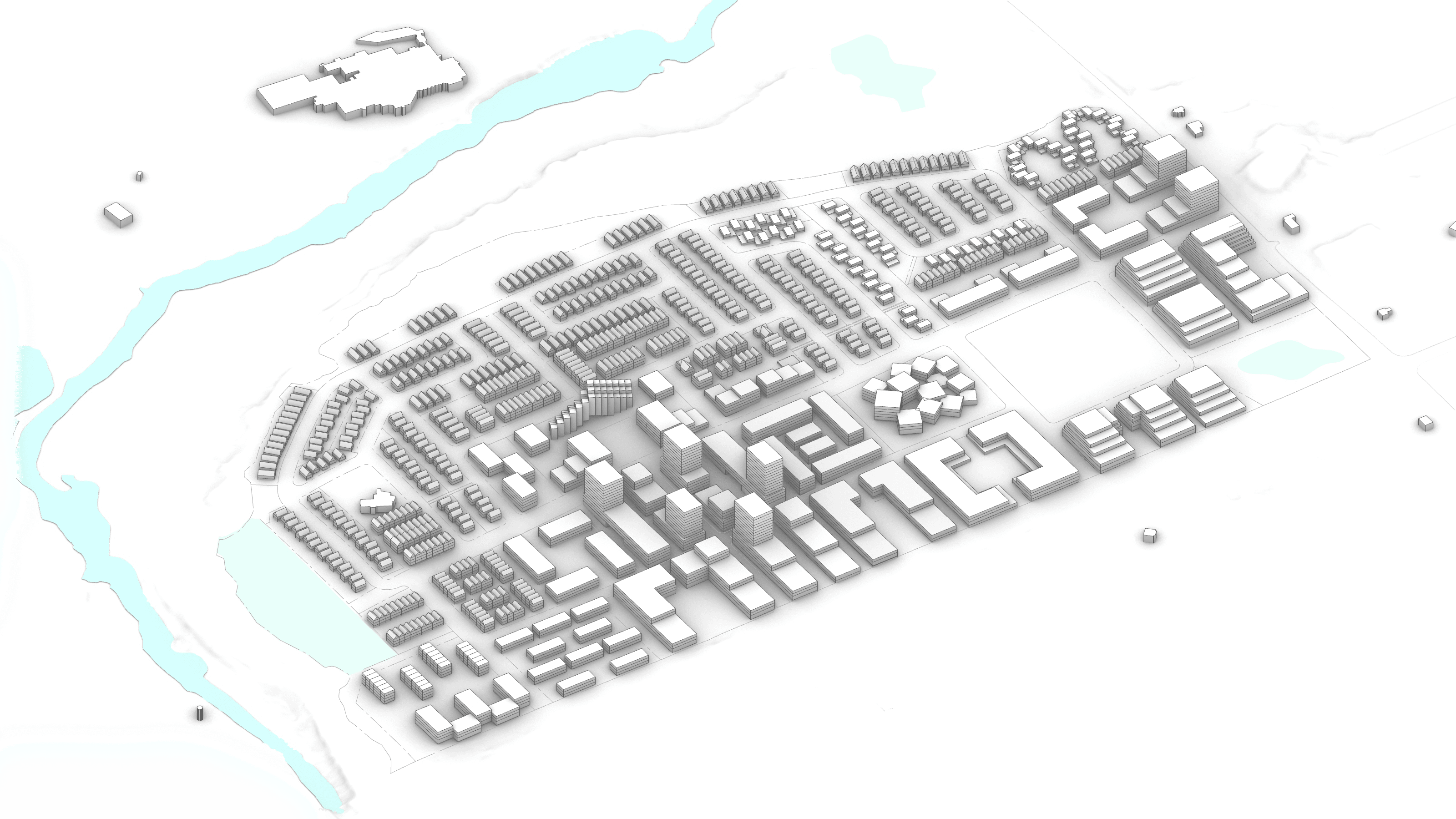
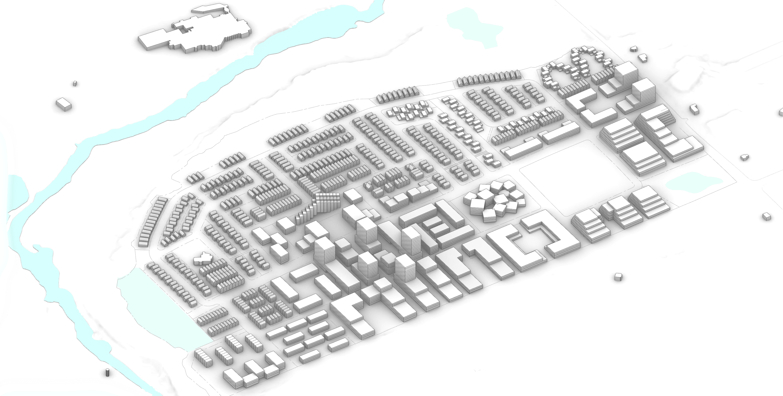
Guelph Innovation District
Partners


Share Your Ideas